


Creative Cartography
Second Grade, 2-3 Weeks
This unit provides students with the opportunity to build upon their knowledge of the Age of Exploration and map reading through a lesson on fantasy cartography. Students will invent their own country and create a map with a legend, compass rose, and details of topography and cities.
Relationship to Life
Students in Second Grade will be learning about geography during their Social Studies lessons. Students will be learning about how to read maps, and will learn how to recognize continents and oceans. Students will learn about the first maps made, and will practice reading maps, recognizing symbols for cities, landmarks, topographical characteristics, compasses, and roads.
Problem/Activity Statement
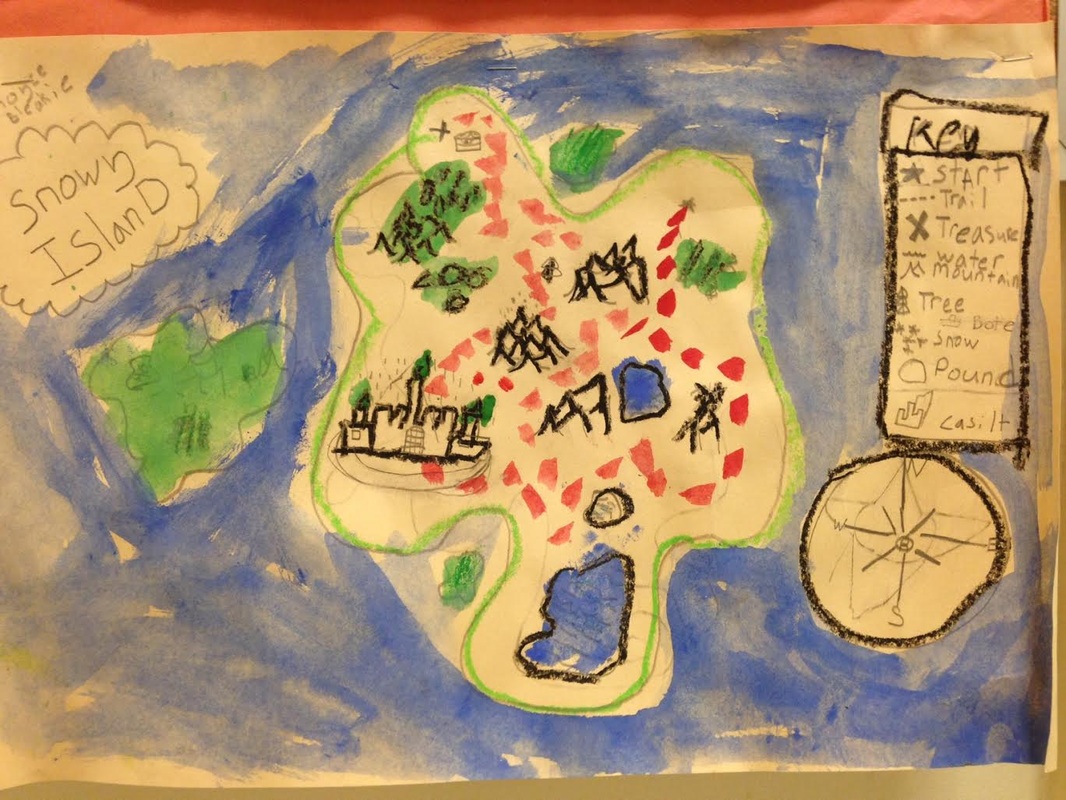
Students are presented with the challenge of inventing an imaginary country, complete with bodies of water, landmasses, forests, roads, cities, etc. Students must write these details for an in-class assignment, and be able to apply these ideas to a hand-drawn map. Students must include personalized symbols that are explained in a key, a decorative compass rose, and should have an image complete with names of locations.
Goals
Students should:
Understand: The meanings of artistic works by explaining how the subject matter and/or form reflect the events, ideas, religions, and customs of people living at a particular time in history
(MCAF Standard 6)
Ways a final product relates to a variety of time images and objects produced in other historical periods.
(MCAF Standards: 5 and 8)
Know: The art making processes necessary to design and create their object.
(MCAF Standard: 4)
Be Able to: Apply knowledge of other disciplines in learning in and about the arts
(MCAF Standard 10)
Produce/construct an object that enables personal voices.
(MCAF Standard: 1)
Objectives
Identify and use ideas of one’s self to communicate through art making.
Use a variety of tools and techniques to apply the formal qualities of art.
Analyze and apply thematic compositional approaches used in designing maps, legends and compass roses.
Demonstrate an understanding of ways artists plan and design personal symbols.
Instructional Concepts
“Cartography is an ancient discipline that dates from the prehistoric depiction of hunting and fishing territories. The Babylonians mapped the world in a flattened, disk-shaped form, but Ptolemy established the basis for subsequent efforts in the 2nd century ad with an eight-volume work on geography that showed a spherical Earth. Maps produced during the Middle Ages followed Ptolemy’s guide, but they used Jerusalem as the central feature and placed East at the top. These representations are often called T-maps because they show only three continents (Europe, Asia, and Africa), separated by the “T” formed by the Mediterranean Sea and the Nile River. More accurate geographical representation began in the 14th century when portolan (seamen’s) charts were compiled for navigation.
The discovery of the New World led to the need for new techniques in cartography, particularly for the systematic representation on a flat surface of the features of a curved surface. The 17th and 18th centuries saw a vast outpouring of printed maps of ever-increasing accuracy and sophistication. Noteworthy among the scientific methods introduced later was the use of the telescope for determining the length of a degree of longitude. Modern cartography largely involves the use of aerial photographs as a base for any desired map or chart; the procedures for translating photographic data into maps are governed by the principles of photogrammetry and yield a degree of accuracy previously unattainable. Satellite photography has made possible the mapping of features of the Moon and of several planets and their satellites.”
Line can be thick, thin or curved.
Line can be used to invent forms.
Color can be used for emphasis in a composition.
Texture can be used to create surface variety.
Forms can be identified by the use of surrounding objects in the environment.
Forms can be described in relation to parts of a while.
Emphasis can be achieved through outlining.
Unity can be achieved through repetition of line, shape, color, texture, space, or form in a composition.
Rhythm can be achieved by varying the size of line, color, texture, shape and form.
Variety can be achieved through a change in tone or value.
Introducing children to art develops their visual awareness and provides a springboard for personal image making.
Narrative strategies help student artists develop their visual awareness and provide a springboard for personal image making.
Brainstorming helps students work through problems and eliminate challenges before working on their final projects.
Resources and Materials
Materials: Exemplars:
Newsprint Teacher Exemplar
Pencils Maps by Connie Brown, Redstone Studios
Cream construction paper
Colored Pencils
Sharpies
Circle template
Motivation
The teacher will have prepared at least one example of their own work to show the class, including a preliminary sketch and a finished map. The teacher will then show students examples of historical maps created as a result of the Age of Exploration. The teacher will ask students to discuss the countries that they invented, and will invite students to discuss points of interest, sources of inspiration, and marks that are successful in describing characteristics of land and man-made features.
Questions
Topic Questions:
What sparked the want and need for maps? Why were early maps inaccurate, and what technologies have helped cartographers create accurate representations?
Is cartography a dying art? Has cartography become a hobby, or is there still a need for man-made maps?
Association Questions:
Do all maps look the same?
What were maps used for during the Age of Exploration? What are some other uses for maps?
Visualization Questions:
What kind of information is important to include in describing topographical features? What kind of information is important to describe cities, towns and roads?
What kind of map would you prefer to make: a functional map or a decorative map?
Transition questions:
What Elements and Principles of Design are most important to remember when designing a map with a legend and compass rose?
Procedures
Demonstration
The teacher will first show students pictures of historical maps made by different artists throughout history. The teacher will then show students the finished teacher exemplar, and the sketch that was used to prepare for the completion of the project. The teacher will have written a description of their invented country, which will be shared with the class. The teacher will explain to students how to draw what has been described in the written part of the assignment, which should have been completed in their regular classroom. After students have completed their sketches, the teacher will show students how to refine their drawings by adding lines, symbols and color to describe topography and landmarks. Students will first draw the outline of their country’s borders, and include information of bodies of water. Students should include a legend on their map to describe symbols used for other map features. Finally, the teacher will show students how to plan a compass rose. Students should embellish and decorate their compass rose using inspiration from historical maps.
Vocabulary:
Cartography- The study and practice of making maps.
Compass Rose- A decorative element on a map used to explain the orientation of the cardinal directions: North, South, East and West. A compass rose may also include NE, SE, NW and SW.
Legend- Also called a “key”, the collection and explanation of various symbols used on a map to describe map features.
Topography- The study of surface shapes of features of Earth, including terrain relief and natural or artificial features such as rivers or roads.
Distribution
Students will first be given sketch paper. They will be instructed to look at the teacher example and the examples of historical maps provided by the teacher. Students should have a copy of their invented country information with them in class to inform their drawings. When students move on to creating their final maps, cream-colored paper, pencils, colored pencils and sharpies will be distributed at each table. Students will keep projects in their folders during the course of the project, and will be responsible for keeping track of projects.
Work period
On the first day, students will be given sketch paper to begin planning their maps. Students will be shown pictures of historical maps to give them inspiration. Students will be asked to utilize information outlined in their regular classroom to influence inclusion of details. Students must plan to include names of regions, bodies of water, cities, etc. Students must also include a legend and a compass rose on their maps. After the first lesson, students will complete a final project on cream-colored paper, made with pencils, colored pencils, and Sharpies.
Clean-up
At the end of each class, students must make sure their names are on their projects. Students must keep their projects in their folders, and are solely responsible for placing their projects in their folders. Any and all materials will be returned to their proper place.
Closure
The teacher will go over what should have been accomplished by the end of the class, and what will be expected of each student during their next meeting. The teacher will review where materials and projects should be put away, and the class will be dismissed.
Evaluation
Students will be evaluated based on their creativity and execution. Students are expected to complete a preliminary sketch before moving on to their final map. The preliminary drawings should demonstrate ability in planning, and should include evidence of brainstorming and development before moving on to the final project. Final maps will be evaluated based on the students’ abilities to organize and lay out their maps with attention paid to details mentioned in the description of their maps. A legend should be included in the design to describe personal symbols used, and a compass rose should be decorated, with the cardinal directions accurately positioned on the compass. Students’ projects should display care in coloring and outlining to distinguish topographic features, as well as labeling of bodies of water, forests, mountain ranges, cities, etc.
Did the students…
Did the students invent an imaginary country, with details such as a name, cities, bodies of water, and other topographical features?
Did the students create a preliminary sketch that represents all of these details?
Did the students create a key to represent symbols?
Did the students design a decorative compass rose, and accurately position the cardinal directions on their compass rose?
Did the students create a final map on construction paper uniting all preparatory work?
Did the students neatly color their maps using colored pencils?
Did the students use Sharpies to outline specific details and write labels for map features?
Relationship to Life
Students in Second Grade will be learning about geography during their Social Studies lessons. Students will be learning about how to read maps, and will learn how to recognize continents and oceans. Students will learn about the first maps made, and will practice reading maps, recognizing symbols for cities, landmarks, topographical characteristics, compasses, and roads.
Problem/Activity Statement
Students are presented with the challenge of inventing an imaginary country, complete with bodies of water, landmasses, forests, roads, cities, etc. Students must write these details for an in-class assignment, and be able to apply these ideas to a hand-drawn map. Students must include personalized symbols that are explained in a key, a decorative compass rose, and should have an image complete with names of locations.
Goals
Students should:
Understand: The meanings of artistic works by explaining how the subject matter and/or form reflect the events, ideas, religions, and customs of people living at a particular time in history
(MCAF Standard 6)
Ways a final product relates to a variety of time images and objects produced in other historical periods.
(MCAF Standards: 5 and 8)
Know: The art making processes necessary to design and create their object.
(MCAF Standard: 4)
Be Able to: Apply knowledge of other disciplines in learning in and about the arts
(MCAF Standard 10)
Produce/construct an object that enables personal voices.
(MCAF Standard: 1)
Objectives
Identify and use ideas of one’s self to communicate through art making.
Use a variety of tools and techniques to apply the formal qualities of art.
Analyze and apply thematic compositional approaches used in designing maps, legends and compass roses.
Demonstrate an understanding of ways artists plan and design personal symbols.
Instructional Concepts
“Cartography is an ancient discipline that dates from the prehistoric depiction of hunting and fishing territories. The Babylonians mapped the world in a flattened, disk-shaped form, but Ptolemy established the basis for subsequent efforts in the 2nd century ad with an eight-volume work on geography that showed a spherical Earth. Maps produced during the Middle Ages followed Ptolemy’s guide, but they used Jerusalem as the central feature and placed East at the top. These representations are often called T-maps because they show only three continents (Europe, Asia, and Africa), separated by the “T” formed by the Mediterranean Sea and the Nile River. More accurate geographical representation began in the 14th century when portolan (seamen’s) charts were compiled for navigation.
The discovery of the New World led to the need for new techniques in cartography, particularly for the systematic representation on a flat surface of the features of a curved surface. The 17th and 18th centuries saw a vast outpouring of printed maps of ever-increasing accuracy and sophistication. Noteworthy among the scientific methods introduced later was the use of the telescope for determining the length of a degree of longitude. Modern cartography largely involves the use of aerial photographs as a base for any desired map or chart; the procedures for translating photographic data into maps are governed by the principles of photogrammetry and yield a degree of accuracy previously unattainable. Satellite photography has made possible the mapping of features of the Moon and of several planets and their satellites.”
Line can be thick, thin or curved.
Line can be used to invent forms.
Color can be used for emphasis in a composition.
Texture can be used to create surface variety.
Forms can be identified by the use of surrounding objects in the environment.
Forms can be described in relation to parts of a while.
Emphasis can be achieved through outlining.
Unity can be achieved through repetition of line, shape, color, texture, space, or form in a composition.
Rhythm can be achieved by varying the size of line, color, texture, shape and form.
Variety can be achieved through a change in tone or value.
Introducing children to art develops their visual awareness and provides a springboard for personal image making.
Narrative strategies help student artists develop their visual awareness and provide a springboard for personal image making.
Brainstorming helps students work through problems and eliminate challenges before working on their final projects.
Resources and Materials
Materials: Exemplars:
Newsprint Teacher Exemplar
Pencils Maps by Connie Brown, Redstone Studios
Cream construction paper
Colored Pencils
Sharpies
Circle template
Motivation
The teacher will have prepared at least one example of their own work to show the class, including a preliminary sketch and a finished map. The teacher will then show students examples of historical maps created as a result of the Age of Exploration. The teacher will ask students to discuss the countries that they invented, and will invite students to discuss points of interest, sources of inspiration, and marks that are successful in describing characteristics of land and man-made features.
Questions
Topic Questions:
What sparked the want and need for maps? Why were early maps inaccurate, and what technologies have helped cartographers create accurate representations?
Is cartography a dying art? Has cartography become a hobby, or is there still a need for man-made maps?
Association Questions:
Do all maps look the same?
What were maps used for during the Age of Exploration? What are some other uses for maps?
Visualization Questions:
What kind of information is important to include in describing topographical features? What kind of information is important to describe cities, towns and roads?
What kind of map would you prefer to make: a functional map or a decorative map?
Transition questions:
What Elements and Principles of Design are most important to remember when designing a map with a legend and compass rose?
Procedures
Demonstration
The teacher will first show students pictures of historical maps made by different artists throughout history. The teacher will then show students the finished teacher exemplar, and the sketch that was used to prepare for the completion of the project. The teacher will have written a description of their invented country, which will be shared with the class. The teacher will explain to students how to draw what has been described in the written part of the assignment, which should have been completed in their regular classroom. After students have completed their sketches, the teacher will show students how to refine their drawings by adding lines, symbols and color to describe topography and landmarks. Students will first draw the outline of their country’s borders, and include information of bodies of water. Students should include a legend on their map to describe symbols used for other map features. Finally, the teacher will show students how to plan a compass rose. Students should embellish and decorate their compass rose using inspiration from historical maps.
Vocabulary:
Cartography- The study and practice of making maps.
Compass Rose- A decorative element on a map used to explain the orientation of the cardinal directions: North, South, East and West. A compass rose may also include NE, SE, NW and SW.
Legend- Also called a “key”, the collection and explanation of various symbols used on a map to describe map features.
Topography- The study of surface shapes of features of Earth, including terrain relief and natural or artificial features such as rivers or roads.
Distribution
Students will first be given sketch paper. They will be instructed to look at the teacher example and the examples of historical maps provided by the teacher. Students should have a copy of their invented country information with them in class to inform their drawings. When students move on to creating their final maps, cream-colored paper, pencils, colored pencils and sharpies will be distributed at each table. Students will keep projects in their folders during the course of the project, and will be responsible for keeping track of projects.
Work period
On the first day, students will be given sketch paper to begin planning their maps. Students will be shown pictures of historical maps to give them inspiration. Students will be asked to utilize information outlined in their regular classroom to influence inclusion of details. Students must plan to include names of regions, bodies of water, cities, etc. Students must also include a legend and a compass rose on their maps. After the first lesson, students will complete a final project on cream-colored paper, made with pencils, colored pencils, and Sharpies.
Clean-up
At the end of each class, students must make sure their names are on their projects. Students must keep their projects in their folders, and are solely responsible for placing their projects in their folders. Any and all materials will be returned to their proper place.
Closure
The teacher will go over what should have been accomplished by the end of the class, and what will be expected of each student during their next meeting. The teacher will review where materials and projects should be put away, and the class will be dismissed.
Evaluation
Students will be evaluated based on their creativity and execution. Students are expected to complete a preliminary sketch before moving on to their final map. The preliminary drawings should demonstrate ability in planning, and should include evidence of brainstorming and development before moving on to the final project. Final maps will be evaluated based on the students’ abilities to organize and lay out their maps with attention paid to details mentioned in the description of their maps. A legend should be included in the design to describe personal symbols used, and a compass rose should be decorated, with the cardinal directions accurately positioned on the compass. Students’ projects should display care in coloring and outlining to distinguish topographic features, as well as labeling of bodies of water, forests, mountain ranges, cities, etc.
Did the students…
Did the students invent an imaginary country, with details such as a name, cities, bodies of water, and other topographical features?
Did the students create a preliminary sketch that represents all of these details?
Did the students create a key to represent symbols?
Did the students design a decorative compass rose, and accurately position the cardinal directions on their compass rose?
Did the students create a final map on construction paper uniting all preparatory work?
Did the students neatly color their maps using colored pencils?
Did the students use Sharpies to outline specific details and write labels for map features?
